Favorite Mountain Biking Trails in Bend, Oregon
We'll show you road and gravel rides, too!
Join our rider-at-large, Don Leet, for these Central Oregon favorites:
"I’ve been asked to write and describe some of my favorite mountain bike trails in Bend, Oregon. A little background first: I love riding my mountain bike--the ups, the downs, the technical, the flowing, and the challenging. But what I really love is the mountain in mountain bikes. I love the views and the scenery more than anything. And I don’t like to shuttle. I’m not morally against it, I'd just rather be on my bike than in a van, so most of my rides will include long climbs, views and thrilling descents." --Don
Gravel ride: Oregon's only unpaved state highway
Spring for me is a time to do some longer road rides, as the roads usually clear up before the trails. I don’t consider myself a gravel grinder, but I don’t mind mixing in a bit of gravel if it means less traffic and good scenery. This ride is one of my favorites.
Park at Four Corners, which is the junction of Reservoir Road and George Millican Road, about 5 miles east of the Alfalfa Store near Bend.
Head east and turn right onto Highway 27 at about 7 miles. Half a mile after the turn is a fun paved descent. There are a couple of cattle guards and usually cattle, so beware. About two miles after the descent the gravel begins. It continues for about 20 miles to Highway 20, with a little over 1000 ft of climbing. I like going clockwise because the descents are paved and the climbing is gravel, and usually the gravel is in good shape. Take note of Little Bear Creek and Bear Creek Roads. Bear Creek Road heads east and gives access to more rides.
When you arrive at Highway 20, turn right (west) towards Bend. You will be on the highway for a little over five miles. It’s flat and pretty fast with good visibility and a decent shoulder. The last time I rode this, only three trucks passed me and a variety of cars. I use a daylight running light system and have had no problems. After the five miles you will get to George Millican Rd. It’s about 14 miles back to the start and mostly downhill (after that first climb).
As you can see, it is hard to get lost on this ride—it’s just three turns. It runs a hair under 50 miles and takes me almost 4 hours. 2000 ft of climbing.
Trail ride: Swampy, North and South Forks (22 miles)
In Bend, with so many miles of individual trails, it is difficult to come up with a route that includes the best trails, is the right distance, and is not too crowded. I came up with this route a few years ago when Skyliner Road was closed for construction. It includes my two favorite climbs, and two of my favorite descents. It’s about three hours of riding time for me and if you time it right (weekdays or early mornings) it's not too crowded.
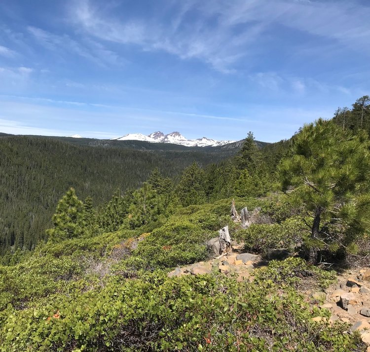
Park at Swampy Lakes, 16 miles from Bend on Century Drive. Take the Swampy Lake trail out of the parking lot, go past Flagline trail, and turn left onto South Fork (2.3 miles). Descend to Tumalo Falls. You will pass the Tumalo Creek trail at the bottom of the descent. At Tumalo Falls stop and enjoy the view and then climb up the North Fork Trail. I heard some riders comment that they were unsure which trail was the North Fork and which trail is the South Fork. I wanted to tell them the North Fork is north of the South Fork.
At Tumalo Falls you will be at mile 6. Climb 4 miles to Happy Valley and turn right onto the Metolius Windigo trail. Continue for a little over 1 mile and you will hit the 370 road. Look to the right and you will see the beginning of the Mrazek trail. Go on this trail for 1 1/2 miles and you will come to another junction. Mrazek continues left but our trail goes right. This is the Farewell trail. The map calls it blue but it is a tricky blue. Be careful and control your speed and you will be fine. There are 5 switchbacks at the bottom which are a good test of one’s skills.
Now you are back at Tumalo Falls. There are a few options here but I usually climb back up South Fork to the car. On this section you might see some descenders. Many shuttle this downhill so keep your eyes and ears open. Common etiquette is for the downhill rider to give way, but I usually move first so they can enjoy their descent and I get to rest.
This is about a 22 mile ride, a little less than 3000 ft of climbing--A good hard ride but not impossible.
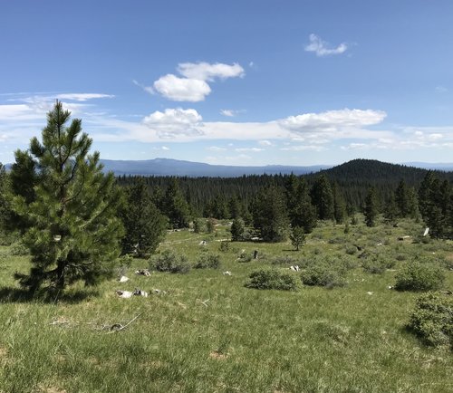
Trail ride: Wanoga area
One of the tricks of riding in Bend, or really any area with an extensive trail system, is to link the different trails together to maximize the fun factor. Mountain biking should be fun--at least for me that is the main goal. In the Wanoga area near Bend, there are three big downhill trails--Funner, Tiddlywinks, and Tyler's Traverse. What many people do is shuttle to the Wanoga Sno-Park and then ride each of these trails. I'm not really into shuttling--I don't like waiting around, I like riding by myself,and I actually enjoy riding uphill. This loop I do has two out of the three downhills--Funner and Tyler's, and I ride up Tiddlywinks. It's a big ride--over three hours, but well worth it. My guess is if you shuttled the two downhills you would spend about the same amount of time.
I start and finish at the the bottom of Tyler's. The uphill of Tyler's is a dedicated uphill-only trail, and it takes about an hour to get to the top. This is the toughest climb so it is good to get it out of the way first. Once you are at the top, take the 10-minute Kiwa trail over to Tiddlywinks. Then continue to the Wanoga Sno-park and descend Funner. Funner is a great trail, much of it is downhill-dedicated, but a warning: there is one mandatory drop. I'm not much of a jumper, so I roll over this drop. I can only say it looks worse than it is.
At the bottom of Funner, I head back up Tiddlywinks to the same Kiwa trail used earlier, and back over to the top of Tyler's. It's now basically downhill to the car. There are a couple of rock gardens to contend with and a couple of steep climbs, but once the main descent starts it is a great flow-style trail that is fun for riders of many skill levels. There will be a smile on your face when you arrive back at your car.
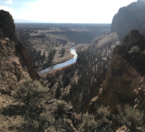
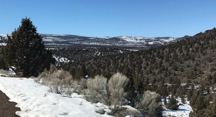
Winter trail ride: Smith Rock to Grey Butte
Many of us who live in Bend ride all winter long. Some ride fat bikes, and COTA grooms trails at Wanoga Snow Park for that. It can be a fun change from riding on dirt. I prefer dirt, however. My ideal ride is a long loop in the desert. We have several areas to choose from: Maston and Cline Buttes, Horse Ridge, and Smith Rock are a few.
A couple of days ago I went to Smith Rock and rode my long loop there, and added some single track to my usual loop.
I start in the Smith Rock State Park Parking lot. You will need a permit to park there—they can be purchased on site if you don’t have one. Ride down the trail to the river, cross the foot bridge and take a left. If it is a busy day you will encounter many hikers. Please be very courteous, in fact even walk some. Those trails get a lot of pressure and we don’t want bikes to be shut out. As you get further from the bridge the number of hikers diminishes quickly, and by the point where the Crooked River starts flowing north, the hikers almost disappear.
As you continue on you will come to the most technical part of the ride. It’s an uphill section on a scree slope. Be careful, but it is mostly rideable. You will be on the back side of the cliffs that you saw from the parking lot. Now you’re at the start of a long climb that includes 17 switchbacks, with eye-popping views. I can ride all of the switchbacks, but the last two are trickier than they appear. One more steep climb, and you will have arrived at the top of Burma Road. Many cyclist ride up the Burma road, but I have vowed to never to ride such a steep and boring road, so I go the long way.
From the top of Burma you are leaving Smith Rock State Park and entering BLM land. The trail is long traverse to Gray Butte that gets no sun in the dead of winter, so watch out for ice. After a couple miles you will come to the Cole Creek loop trail that takes off to the right. It crosses a road and heads downhill. On a good day this is a super-fun descent of about two miles. This trail can also be icy or even muddy. When you get to the bottom, cross the road and continue on the trail to the Skull Hollow trail head. Look to the left and you will take the Cole Creek trail that goes east. This trail will have more horse use but it is mainly a nice uphill. This avoids the steep road climb towards Gray Butte, but it adds about half hour of riding time. After about three miles you will be riding parallel to a road. Be careful not to follow this trail too far. You will cross a main road and then take left, which will take you up to the old Orchard homestead and the Gray Butte trail head. You will now take the trail back towards Smith Rock. The sign says Smith Rock 7.5 miles, but it is actually 11 miles back to the parking lot. You will climb about 400 ft and then mainly descend as you loop around Gray Butte. When you come to a gate, go through it. In about a mile. after a couple of fun descents you will return to where you finished the traverse and descended to Skull Hollow. Then just retrace your route back to the starting point.
Practice your switchbacks on the way down, and watch out for the hikers as you get close to the finish. The climb from the bridge to the parking lot is killer, the last bit being over 20%. This ride takes me about 4 hours and it is 27 miles long. Enjoy!
P.S. If you don’t want to park at Smith Rock, you can start and finish this ride from the Skull Hollow Trail Head.
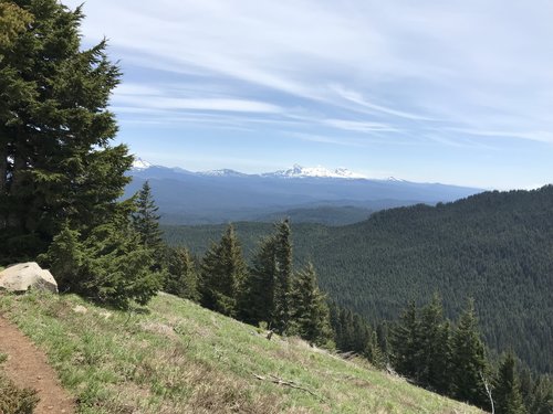
Trail ride: South side, Crescent mountain
Here is number one: South Side of Crescent Mountain. It’s west of Santiam Pass in an area called the Old Cascade Crest. That’s because it was the crest before these youngish volcanoes popped up. Go over Santiam Pass, take a left at the Santiam Y and then go straight at the Clear Lake Cutoff towards Sweet Home and Corvallis. Take a right at Lava Lake Sno-park about half a mile after the intersection. Stay on the one-lane paved road past the Sno-park (Road 2067) for about a mile. Follow signs to the trailhead up the gravel road (508). Trailhead is up about half a mile.
There are many variations of this ride. My GPS here shows the shortest: 4 miles up and 4 miles down. It not quite a 2-hour ride if you go my pace. There are lots of hike-a-bike ups in a beautiful setting, and swoopy downhills with sidehills, switchbacks and fun. Not many rocks, and nothing really technical unless you go too fast.
Another variation would be go down the north side and then return up and back down. This would be twice as long. The north side is a bit more technical but not over the top.
A third variation would be to add some of the other Old Cascade trails.
This ride is not for the faint of heart, but for someone who likes to climb and feels, like I do, that if you don’t hike-a-bike you are not on a real ride.
Enjoy.
Side note. I am a little hesitant to put this ride out there as it is very pristine. Please treat the trail gently.